
The U.S. Army Corps of Engineers recommended last week that FEMA re-certify the levees protecting the Hinds and Rankin County edges bordering the Pearl River, despite the fact that the levees cannot stop a 200-year flood event similar to the 1979 Pearl River flood.
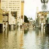
In April 1979, a massive low-pressure weather system dumped eight inches of rain on the city of Jackson in only 24 hours. The resulting record flood inundated the fairgrounds area, some residential areas in northeast Jackson and a small portion of the central business district, doing more than $200 million in damage.
The Corps specifically based its approval for levee certification on a 1 percent annual average flood level of about 87,000 cubic feet per second, rather than the 128,000 cubic feet per second flow of the 1979 200-year flood. That standard puts the elevation of the lowest top of levee along both the east and west banks of the Pearl River safely between two and three feet. The levees, however, are still incapable of handling a flood event such as in 1979.
Corps spokesman Kavanaugh Breazeale said an event like the 1979 flood is extremely rare and counts as "a 200-year flood."
The Corps found the levees would protect against a more typical flood, even after inspecting evidence of "obvious settlement, misalignment, joint separation, exposed reinforcement, spalling of concrete, holes or cracking in the pipe."
"Our findings are that the levee systems meet all of the requirements established by USACE for determining that the levee system can be reasonably expected to protect against the 1 percent chance flood event on the Pearl River," Corps District Commander Jeffrey Eckstein wrote in his Feb. 23 letter to the Federal Emergency Management Agency.
Human Error in 1979
The strength of the levees was not the factor leading to the devastation of the 1979 flood, however; they never broke or cracked. Later that year, the U.S. General Accounting Office--the non-partisan congressional investigative and research office--released a report on the Easter flood. The report outlined that no "lines of communication nor coordination procedures had been established between the reservoir manager and the Corps, even though the reservoir's discharge rate could affect the flood-fighting responsibilities of the two entities."
On April 14, three days after a low-pressure weather system first doused Jackson with four inches of rain before moving on to create floodwater in the northern Pearl tributaries, the Corps' Reservoir Control and Meteorology Section began advising the Pearl River Valley Water Supply District manager on maximizing the reservoir's storage capacity and avoiding a dam failure. It was the first time the two agencies had communicated prior to the 1979 flood.
The Corps' operation manual directs engineering personnel to involve themselves in dam management whenever the district becomes aware of potential dam failure, but the GAO investigators found "no indication that the Corps had determined the impact the reservoir and dam could have on its levee project (until) well after the initial flood warning of April 12, and after the reservoir manager began his own flood control actions."
The Corps responded this week that it now follows its policy guideline of contacting the district at the time of first notification of potential dam problems. Pearl River Valley Water Supply District General Manager Benny French agreed that the two entities had practically no history of communication prior to the 1979 flood, but added that the flood "certainly opened the lines of communication."
Numerous conflicting flood-crest predictions by three different federal agencies also presented problems at the time. The National Weather Service predicted a crest of up to 39.5 feet, while the U.S Geological Survey and the Corps forecast a crest level of up to 42.1 feet--all of them shy of the actual 43.3 feet. NWS and USGS were unable to reconcile their forecasts to provide the reservoir manager an official prediction of reservoir water inflow data, causing some consternation over the amount of water to release from the dam in preparation.
French said the District now gets its official information from the National Weather Service. "There was so much confusion going on back in that period because we were all witnessing something we had never seen before, and there was a lot of guessing going on by people making statements, but it's been the National Weather Service giving us our information," French said.
The Traitorous Sewers
The GAO report also states that much of the 1979 flood water invaded the city through Jackson's own traitorous sewer system. City administration, under then-Mayor Russell Davis, had installed a new 66-inch sanitary sewer in 1975, which passed directly through the Jackson levee. The city attempted to stop the flow of all sewage into the 66-inch line when floodwater began gushing through the fairground manholes; however, the valve failed to stop the flow of water through a 48-inch junction line connected to the 66-inch pipe.
Levee Board member and Two Lakes Foundation supporter Leland Speed recently pointed to the amount of filthy water backing up into the city from the sewers as a means to garner support for Two Lakes developers' promise to contain future floodwater in the Pearl. Speed argued that the lake plan, estimated by the Corps to cost $1.4 billion, would alleviate the issue.
"See this black water area inside the city?" Speed asked the board in January, while hefting a large photo of the inundated city. "All that nasty brown water didn't come over the levee. It came right up through our sewers. This is exactly the kind of problem (a levee expansion) would lead to (without expensive upgrades)."
Sierra Club Executive Director Louie Miller, an opponent of the lakes plan due to its massive environmental impact, derided the city's Public Works Department for its bad 1975 decision when they installed the pipe.
"They built a sewer line that they didn't even have permission to build," Miller said. "Believe it or not, they basically bored a hole through their own levee so the folks moving into north Jackson could send their sewage to a treatment plant in south Jackson, and the way the report reads, they didn't even get permission to build the damn thing."
The GAO report reveals that the city had no record of a permit from the local levee board to build the 66-inch pipe.
Dale Danks Jr. was mayor at the time of the 1979 disaster. He said this week that his administration upgraded the faulty sewer line with federal funds soon after the flood. "We fixed the sewer line, but it wasn't the sewer that did the damage. It was that levee around Fortification Street where the water came in," said Danks, who lobbied to transfer responsibility for Jackson flooding from the Corps district in Moble, Ala., to Vicksburg.
A Diminutive Expansion
Even though floodwater flowed over the levees in multiple locations at the height of the event, water first flanked the north end of the Jackson levee near Fortification Street in clear view of multiple flood-control entities--who did not make an early attempt to sandbag the area. The report points out that "responsibility for constructing a sandbag or dirt closure at Fortification Street was unclear."
"We've fixed that," assured Levee Board Chairman Billy Orr. "We extended the levee behind Fortification Street. You can see it when you get on that off-ramp over there. Look to your right."
Despite numerous improvements, the question as to the effectiveness of the levees in the event of another 1979 cataclysm remains. But the Corps temporarily sidestepped the issue by adopting a lower standard of measurement in last week's certification--perhaps because not certifying would not immediately change anything but flood insurance rates.
The Corps' may have been more likely to recommend certification since the Levee Board voted 5-to-2 in December to expand levees rather than pursue a more expensive lake plan that could wind through court for many years, leaving the area with no flood improvements and the Corps open for more New Orleans-style criticism should the worst happen in the meantime. The Corps made plain at a September 2009 meeting with the Levee Board in Vicksburg that it may well de-certify the levees if the Levee Board could not move on a flooding solution.
The Corps says it did not use de-certification issues as a way to get a levee plan moving. "The Corps evaluates the levees. They inspect them, but certification comes from FEMA," Breazeale said in January. "...(Corps Chief of Project Management Doug) Kamien said he doesn't have the power to do that."
Regardless, the certification is good news to homeowners. Without it, home insurance rates would dramatically rise.
"You wouldn't want those levees to go uncertified," said insurance agent Hank Aiken, the owner of a business in the flood plain inundated in 1979 . "If the FEMA flood map gets re-worked with uncertified levees, homes that never needed flood insurance would suddenly need it, and it wouldn't come cheap."
But the issue of how to handle another 1979 monster flood remains an issue, especially considering the growing intensity of precipitation over the last decade.
Mississippi native Mike Tidwell, founder and director of the Chesapeake Climate Action Network and author of the book "The Ravaging Tide: Strange Weather, Future Katrinas, and the Coming Death of America's Coastal Cities," said the immediate future will likely contain a host of 200-year floods becoming 100-year, or even 50-year floods.
"There is now 5 percent more moisture in the atmosphere than there was 100 years ago and a 4 percent increase in atmospheric moisture just since the 1970s. That's resulting in the increase of extreme precipitation events," Tidwell said, adding that the situation was further aggravating weather systems that were already angry.
"Across much of the U.S. there's observed evidence that extreme precipitation events are on the rise," he said.
"There's no reason to think that the central area around Jackson would not see the results of this."
Previous Comments
- ID
- 156513
- Comment
I have not read parts 1 and 2 of this series, but Mr. Lynch makes a great deal of the 4 inches of rainfall Jackson received contributing to the Easter Flood of 1979. Although this precipitation doubtlessly increased the flooding, most of the flood water came from the north end of the Pearl River drainage basin. As I recall, Philadelphia received 13 inches of rain, Louisville 17 and Kosciusko 21 inches. That unprecidented precipitation event had nowhere else to go than through the Ross Barnett Reservoir spillway.
- Author
- pogopossum
- Date
- 2010-03-04T09:26:07-06:00
- ID
- 156516
- Comment
Does anyone remember anything about the Bass Tournament that was scheduled around the time of the Easter Flood of 1979.
- Author
- justjess
- Date
- 2010-03-04T11:28:33-06:00
- ID
- 156517
- Comment
Jess- Nope, but why do you ask?
- Author
- BubbaT
- Date
- 2010-03-04T11:39:53-06:00
- ID
- 156520
- Comment
I do Jess. I don't remember first hand but I remember someone blaming the flooding on the way the Dam Operator handled the reservoir levels to optimize bass fishing. That was just what someone told me though. I was a kid at the time. I also heard that the Jackson levee did fail. What I was told exactly was that they were about to blow-up the levee on the Rankin county side of the river when the levee on the Jackson side failed.
- Author
- WMartin
- Date
- 2010-03-04T12:06:47-06:00
- ID
- 156521
- Comment
WMartin, thanks for your recollection of hearing about the bass tournament and its relationship to the flood. This is the story that was floated during the Easter Flood of 1979. For fear of losing my "credibility", I decided to ask before depending on my personal storage of information. LOL!
- Author
- justjess
- Date
- 2010-03-04T12:38:46-06:00
- ID
- 156524
- Comment
Mr. Martin, I think someone told you wrong--the reservoir levee did not fail. It was strained to its limit...water was about to go over the emergency spillway when workers sandbagged it. If the levee had failed, there is no telling how high the flood would have gone--maybe as high as 45-50 feet.
- Author
- pogopossum
- Date
- 2010-03-04T13:21:35-06:00
- ID
- 156525
- Comment
I have no doubt that it was just a rumor. I was 11 at the time and there was plenty of that stuff floating around, if you will pardon the pun. But it wasn't the Spillway Dam they were talking about it was the levee on the hinds county side of the river at Jackson.
- Author
- WMartin
- Date
- 2010-03-04T13:30:18-06:00
- ID
- 156527
- Comment
With the reservoir silting up and only being 10 ft deep, its becoming less and less a reservoir and just a scenic body of water. The footprint of the rez could diminish 25% if we have an extreme drought like Atlanta or Austin had recently. The Harbor Walk development project may b foundering if they c the next 30 years as a slow death of its water resource and recreation capability. Valencia Hotel may have passed on Harbor Walk 4 the reasons mentioned. Reservoirs have a 90 year lifespan so ours is almost at retirement age. A floodway canal running by the airport and starting at the blowout and reentering the river near Bryam is one expensive solution. 2 lakes is not a solution at all unless the floodway is done.
- Author
- Aeroscout
- Date
- 2010-03-04T14:20:11-06:00
- ID
- 156530
- Comment
Also, here is the link to the GAO report. I'm sorry we didn't include the link earlier. I'll add it above as well.
- Author
- DonnaLadd
- Date
- 2010-03-04T15:19:25-06:00
- ID
- 156564
- Comment
First, I want to commend Adam and Ladd on all the excellent reporting you guys have done over the years on this issue. You guys are the standard bearers for reporting on this, and I think you're doing a great service to this community with the thoroughness of your work. I am a hydraulic engineer, and I love spending time down by the river on the trails, so I have both a personal and a professional interest in what happens to it. Unfortunately, I have never had the time to really study the issue from an engineering perspective, because to do it justice requires a significant investment of time and energy, and I am perpetually overworked as it is. However, one thing I have wanted to know for quite some time is whether or not some simple modifications to the existing configuration of the river have been considered, that by themselves could greatly improve the conveyance of the main channel through town. Specifically, has the impact of the removal of the constriction and weir at the old water intake been investigated? Or the removal of the abandoned railroad trestle just downstream? These two constrictions are significant impediments to flood flow, and their removal could only improve the conveyance of the channel. I realize that removing the weir would impact much more than just flooding: for example, it would impact the frequency of inundation of upstream riparian cypress wetlands. But if the impacts were investigated, at least we would know what level of flood protection would be gained by these (relatively) inexpensive removal actions. Anyway, just curious if you know whether or not the removal of these constrictions has ever been systematically investigated.
- Author
- GLB
- Date
- 2010-03-06T15:47:00-06:00
- ID
- 156565
- Comment
GLB, thanks very much for your input and the compliment. This issue is too important not to dig deep into, and we are nowhere near done. Any and all serious input and guidance is appreciated. I'd love to talk to you more. Can you e-mail me at [email protected]? Thanks again.
- Author
- DonnaLadd
- Date
- 2010-03-06T17:57:47-06:00
More stories by this author
Support our reporting -- Follow the MFP.

Comments
Use the comment form below to begin a discussion about this content.
comments powered by Disqus